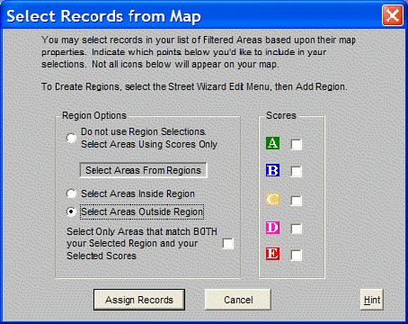
Select Records From Map is an advanced feature to select records in the Summary Report based on attributes displayed on a map of the selected areas. There are three different criteria to use.
Region Options specifies how to assign records which fall within regions (polygons) drawn using the Street Wizard's Edit Menu and Add Region option. Multiple polygons are drawn to include or exclude specific groups of records. However, these drawn regions are not required in order to use the Select Records feature.
Do not use Region Selections is the default region option. This causes the Assign Records function to use only the Scores or Drive Times selections.
Select Areas Inside Region selects all areas inside the drawn region to be included in the Assign Records function.
Select Areas Outside All Region selects all areas outside the drawn region to be included in the Assign Records function and all areas inside the polygon to be excluded.
Select Only Areas that match BOTH your Selected Region and your Selected Scores acts like a Boolean AND. It causes the Assign Records function to only select a record if it falls within the region selection AND meets any Score or Drive Time restrictions specified
Scores selects a single or multiple score, as seen on the map, and finds all records which have that score. For instance, to export all records that have a Score of A or B, check the boxes by A and B and click on the Assign Records button to select those records. Go to the Output List option and choose to output Selected Records.
Drive Times (not shown) selects a single or multiple score as seen on the map to find all records which have that same drive time. For instance, to do a Study Total of all records with a drive time of 15 minutes or less, check the boxes by any of the drive times 15 minutes or less and click on the Assign Records button. This will automatically select those records. Go to the Study Totals option and choose to Include Selected Records.